IDENTIFICATION AND LOCATION
Cerro Masatrigo is a unique geological formation located in the municipality of Esparragosa de Lares, in the northeast of the province of Badajoz, within the districts of La Siberia and La Serena. It is surrounded by the waters of the La Serena reservoir, at the confluence of the dammed courses of the Zújar and Guadalemar rivers, which accentuates its island-like appearance and makes its silhouette one of the most recognisable landscapes in Extremadura.
It was declared a Natural Monument of Extremadura by Decree 65/2023 of 24 May, published in the Official Gazette of Extremadura on 30 May 2023.
With its almost perfect conical geometry, Cerro Masatrigo is one of the most distinctive landscape landmarks in Extremadura and a visual reference point of the La Siberia Biosphere Reserve.
HISTORY AND TRADITION
Cerro Masatrigo also has historical and symbolic interest. Some historians link its importance to the presence of the Knights Templar in the nearby Sierra de Lares, suggesting that it may have been regarded by the Templars as a “magical mountain”.
There are several theories about the origin of its name. Some link it to the Galician term “amaçatrigo”, associated with millstones because of its formal similarity; other interpretations refer to the expression “masa de trigo” because of its conical shape, or to the existence of former flour mills in the area around the Guadalemar river.
Beyond these interpretations, Cerro Masatrigo has become one of the great landscape symbols of Extremadura and one of the most recognisable natural enclaves in the province of Badajoz.
NATURAL AND GEOLOGICAL FEATURES
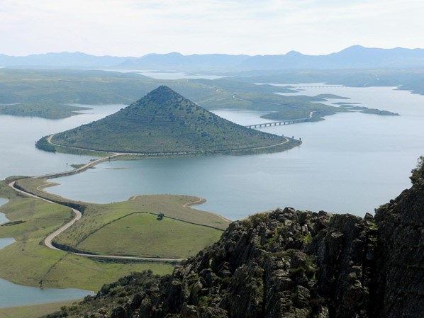
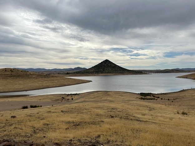
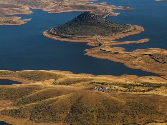
Cerro Masatrigo has an exceptional morphology within the Iberian landscape. It is a very clearly defined conical elevation, crowned by quartzite materials resistant to erosion and surrounded by the sheet of water of the La Serena reservoir, a circumstance that further reinforces its isolated and monumental appearance.
According to the Decree declaring it a Natural Monument, it reaches an altitude of 528 metres above sea level and rises approximately 176 metres above the water surface when the reservoir is at its maximum level.
From a geological point of view, it is formed mainly by Palaeozoic quartzites from the Ordovician period in its upper area, and by Quaternary deposits of blocks, pebbles and sands on the slopes and lower areas. Its current configuration is the result of erosive processes developed over thousands of years, favoured by the mineralogical composition of the terrain and by its location next to the former meander of the Guadalemar river.
Before the construction of the Zújar and La Serena reservoirs, the hill was already a landscape landmark in the area, although it was the creation of the reservoir that eventually turned it practically into an island and enhanced its iconic image.
LANDSCAPE AND SCENIC VALUE
Cerro Masatrigo is considered one of the most spectacular natural landscapes in Extremadura. Its conical silhouette rising above the waters of the La Serena reservoir has turned this enclave into a territorial symbol of La Siberia and La Serena.
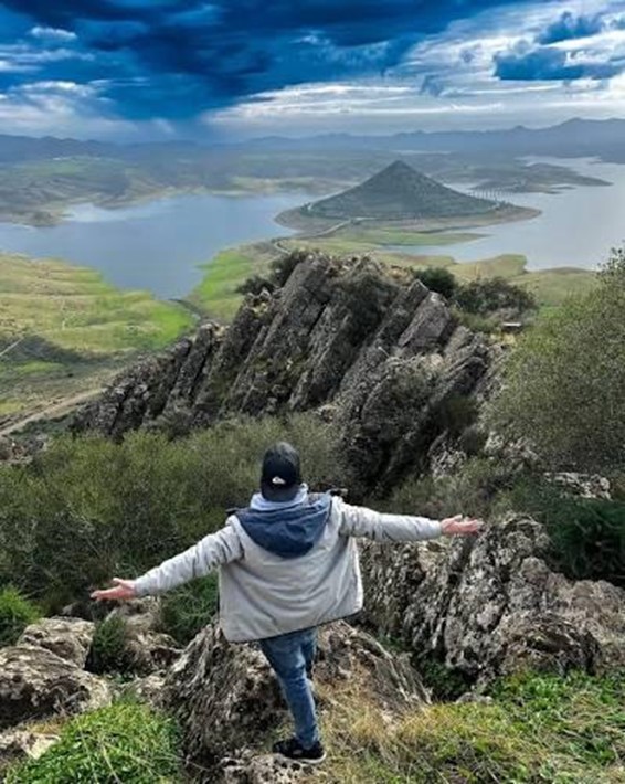
From its summit there are wide panoramic views of the La Serena reservoir, the surrounding mountain ranges and extensive areas of both districts. The broad visual scope of the surroundings makes it possible to contemplate a landscape characterised by large bodies of water, dehesas, quartzite mountain ranges and areas of high environmental quality.
The geometric singularity of the hill has meant that it has often been used as a setting for reports, promotional campaigns and audiovisual recordings, as well as becoming one of the most photographed landscapes in the province of Badajoz.
NATURAL MONUMENT OF EXTREMADURA
On 24 May 2023, the Junta de Extremadura officially approved its declaration as a Natural Monument, making it the sixth site in Extremadura to be recognised under this environmental protection category. The declaration expressly recognises its extraordinary geological, landscape and environmental singularity, as well as its historical and cultural relevance for the districts of La Siberia and La Serena.
The protected area covers approximately 82.93 hectares and forms part of the Natura 2000 Network, being integrated within the SPA “Embalse de La Serena” and the SAC “La Serena”.
FLORA AND VEGETATION
The surroundings preserve an important representation of the sclerophyllous Mediterranean woodland characteristic of the area, dominated by holm oaks and wild olive trees, accompanied by Mediterranean scrub and grasslands historically associated with traditional livestock farming. In the middle and lower areas there are also small stands of stone pine resulting from the forest repopulations carried out during the 1990s by the Guadiana Hydrographic Confederation.
The historical presence of sheep farming favoured the development of grasslands and majadales of high ecological and livestock value, shaping a landscape representative of the traditional use of these Extremaduran districts.
FAUNA AND BIRDLIFE
Cerro Masatrigo is of notable ornithological interest because it is part of an important protected area for birds. The waters of the reservoir and the rocky and woodland environments of the surrounding area favour the presence of numerous species. Among the most representative birds are the black stork, white stork, griffon vulture, golden eagle, Bonelli’s eagle, Egyptian vulture, red kite, black kite, common crane, blue rock thrush, black wheatear, grey heron, great crested grebe, mallard and kingfisher.
The site is also a hunting and foraging area for large birds of prey and a point of interest for observing aquatic birds linked to the La Serena reservoir.
HIKING AND PUBLIC USE
One of the main public-use resources is the Masatrigo Botanical Trail (SL BA-198), which allows visitors to climb to the summit of the hill and explore part of its natural surroundings.
The route is approximately six kilometres there and back and offers two alternatives:
• A perimeter route of lower difficulty and moderate gradient.
• A direct ascent to the summit with a more demanding route and a steep gradient.
The summit has natural viewpoints from which wide panoramic views of the La Serena reservoir and the districts of La Siberia and La Serena can be enjoyed.
THE “LARGEST ROUNDABOUT IN EUROPE”
One of the most striking elements associated with Cerro Masatrigo is the EX-322 road, which completely surrounds the base of the hill, forming a large circular ring approximately 1.3 kilometres in perimeter.
This unusual road layout emerged after the construction of the La Serena reservoir, when it became necessary to redesign the former route between Puebla de Alcocer and Cabeza del Buey. The road fully circles the hill and connects the northern and southern ends of the route by means of bridges.
It is popularly known as “the largest roundabout in Europe” and is one of the most characteristic and identifiable elements of the Masatrigo landscape.